How to read a sectional chart for the Part 107 test
For the Part 107 test you mainly read three things on a sectional: the airspace boundary around your site, the airport's color and data block, and obstacle heights. The boundary tells you whether 14 CFR 107.41 requires ATC authorization; Class B, C, D and Class E surface areas do.
Start with the basics: scale, units and colors
A sectional is drawn at a scale of 1:500,000 and is named after a major city in its area. The FAA's Aeronautical Chart Users' Guide sets the defaults: "Unless otherwise indicated, miles are nautical miles (NM), altitudes indicate feet above Mean Sea Level (MSL), and times used are Coordinated Universal Time (UTC)."
Color tells you about the airport before you read anything else: "Airports with Control Towers (CT) and their related data are shown in blue. All other airports and their related data are shown in magenta." A blue airport has a control tower. A magenta airport does not.
Airspace boundary line styles: Class B, C, D and E surface
| Airspace | How the sectional shows it | Altitude labels |
|---|---|---|
| Class B | Solid blue boundary lines around each sector | Floor and ceiling in solid blue figures, MSL, last two zeros omitted. 70 over 25 means 2,500 to 7,000 feet MSL. |
| Class C | Solid magenta boundary lines | Floor and ceiling in solid magenta figures, MSL, last two zeros omitted. A ceiling of "T" means up to, but not including, the floor of the Class B above. |
| Class D | Blue dashed line | Ceiling in hundreds of feet MSL in a dashed box. A minus sign, such as -27, means from the surface up to but not including 2,700 feet MSL. |
| Class E surface area | Magenta dashed line | Starts at the surface. |
| Class E, 700 ft AGL floor | Magenta vignette (a shaded band) | Controlled airspace begins 700 feet above the ground. |
| Class E, 1,200 ft AGL floor next to Class G | Blue vignette | Class E "exists at 1200' AGL unless designated otherwise." |
For Class B, the guide adds that floors "extending 'upward from above' a certain altitude are preceded by a (+). Operations at and below these altitudes are outside of Class B Airspace."
When ATC authorization is required (14 CFR 107.41)
The rule is short: "No person may operate a small unmanned aircraft in Class B, Class C, or Class D airspace or within the lateral boundaries of the surface area of Class E airspace designated for an airport unless that person has prior authorization from Air Traffic Control (ATC)."
| Your site is inside | Prior ATC authorization needed? |
|---|---|
| Class B (solid blue) | Yes |
| Class C (solid magenta) | Yes |
| Class D (blue dashed) | Yes |
| Class E surface area for an airport (magenta dashed) | Yes |
| Magenta vignette only, flying at or below 400 ft AGL | No. Controlled airspace there starts at 700 ft AGL, above a small UA's normal altitude limit. |
| Class G near a non-towered airport | No, but you must not interfere with airport traffic (14 CFR 107.43). |
AC 107-2A says: "Unless the flight is conducted within controlled airspace, no notification or authorization is necessary to operate a small unmanned aircraft at or near an airport." It also says that information on the current authorization process is available at https://www.faa.gov/uas/.
Reading the airport data block
The Chart Users' Guide illustrates a towered airport with this data block:
CT - 118.3 ★ Ⓒ ATIS 123.8
285 L 72 122.95
- CT - 118.3: control tower primary frequency.
- Star after the tower frequency: "Star indicates operation part-time. See tower frequencies tabulation for hours of operation."
- C in a solid circle: the CTAF symbol. It follows the frequency to use as the Common Traffic Advisory Frequency.
- 285: airport elevation in feet MSL. The guide defines it as "the highest point on the usable portion of the landing areas."
- L: lighting in operation sunset to sunrise. *L means lighting limitations exist; check the Chart Supplement. A dash means no runway edge lights.
- 72: length of the longest runway in hundreds of feet, so about 7,200 feet.
- 122.95: the aeronautical advisory station (UNICOM).
Runway length uses a 70-foot rounding point: "a runway 8070' in length is charted as 81, while a runway 8069' in length is charted as 80." The same rule means a 4,570-foot runway is charted as 46 and a 4,569-foot runway as 45. When information is missing, the guide says the character is replaced by a dash.
Finding the CTAF at towered and non-towered airports
The FAA study guide defines a CTAF as "a frequency designated for the purpose of carrying out airport advisory practices while operating to or from an airport without an operating control tower. The CTAF may be a UNICOM, MULTICOM, FSS, or tower frequency."
On a magenta (non-towered) airport, find the frequency followed by the C symbol. On a blue airport with a part-time tower, look at what the C symbol follows; in the guide's example it follows the tower frequency, so 118.3 is used as the CTAF when the tower is closed. One of the FAA's own sample questions for the new test format asks exactly this.
Part-time Class D airspace
A Class D boundary drawn around an airport with a part-time tower carries a note. The Chart Users' Guide says "Class D operating less than continuous is indicated by the following note", and its example reads "See NOTAMs/Supplement for Class D eff hrs". Class E surface areas that are part time carry a similar note.
To work out which airspace applies at a given time, combine three items: the star after the tower frequency, the tower hours in the chart's tower frequencies tabulation, and the Chart Supplement or NOTAMs the note points you to. Test questions can ask what applies when a part-time tower is closed (one FAA sample asks for the CTAF in that case), so check the hours rather than assuming the Class D boundary is always in effect.
Obstacles: MSL on top, AGL in parentheses
Sectionals typically show man-made obstacles more than 200 feet AGL (more than 299 feet AGL in yellow city areas). Next to an obstacle, "The AGL height is in parentheses below the MSL elevation." A tower labeled 1549 over (349) has its top at 1,549 feet MSL and stands 349 feet above the ground. "UC" means under construction or reported but not verified. In crowded areas the AGL value may be left off.
Each quadrant also carries a Maximum Elevation Figure (MEF): the highest elevation within the quadrant, including terrain and obstacles, rounded up to the nearest 100 feet with the last two digits not shown.
Fly Part 107 is a free practice site for the UAG knowledge test. It has 520 questions with an explanation for every answer, including 120 chart questions built on ten current FAA sectionals (October 29, 2026 edition) with zoom, plus the Chart Trainer, the Read the Question trainer and a cited cheat sheet. Chart questions carry the chart name and edition dates in the caption, the way the FAA's new questions do. A one-time $49 payment gives lifetime access to full 60-question practice tests with 5 unscored items.
Try these practice questions
A remote pilot reviewing a sectional sees a Class B sector labeled with the solid blue figures 80 over 30. What are the vertical limits of that sector?
- 3,000 feet AGL to 8,000 feet AGL
- 3,000 feet MSL to 8,000 feet MSL
- 300 feet MSL to 800 feet MSL
Show the answer
Answer: B. B is correct: the Chart Users' Guide says Class B ceiling and floor altitudes are MSL and shown with the last two zeros omitted, so 80 over 30 is a floor of 3,000 feet MSL and a ceiling of 8,000 feet MSL. A is wrong: the figures are MSL, not AGL. C is wrong: it ignores the two omitted zeros.
Why the other answers miss
- A. Class B figures are MSL altitudes, not heights above ground.
- C. Forgets that the last two zeros are omitted on the chart.
A remote pilot's planned site lies inside a blue dashed line around an airport on the sectional. Which airspace is this, and what does Part 107 require?
- Class D; prior ATC authorization is required
- Class E surface area; no ATC authorization is required
- Class G; notify the airport manager before flight
Show the answer
Answer: A. A is correct: the Chart Users' Guide says Class D is identified with a blue dashed line, and 14 CFR 107.41 requires prior ATC authorization to operate in Class D. B is wrong: a Class E surface area is a magenta dashed line, and it too requires ATC authorization under 107.41. C is wrong: a blue dashed line is not Class G, and Part 107 has no airport-manager notification rule.
Why the other answers miss
- B. Class E surface areas are magenta dashed, and still need ATC authorization.
- C. A blue dashed line is Class D, not Class G; there is no airport-manager notice rule.
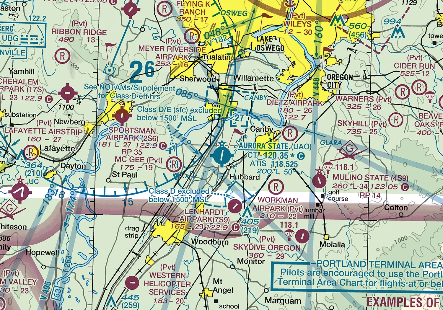
What type of airspace is at the surface at AURORA STATE (UAO) while the control tower is in operation, and is ATC authorization required to operate a small UA there?
Refer to the image below to answer the question.
- Class D, and ATC authorization is required.
- Class G, and ATC authorization is not required.
- Class E surface area designated for the airport, and ATC authorization is required.
Show the answer
Answer: A. The chart shows the airport surrounded by a dashed blue line, which depicts Class D. Under 14 CFR 107.41, operating in Class B, C or D airspace, or within the surface area of Class E designated for an airport, needs prior ATC authorization (for example through LAANC or FAADroneZone).
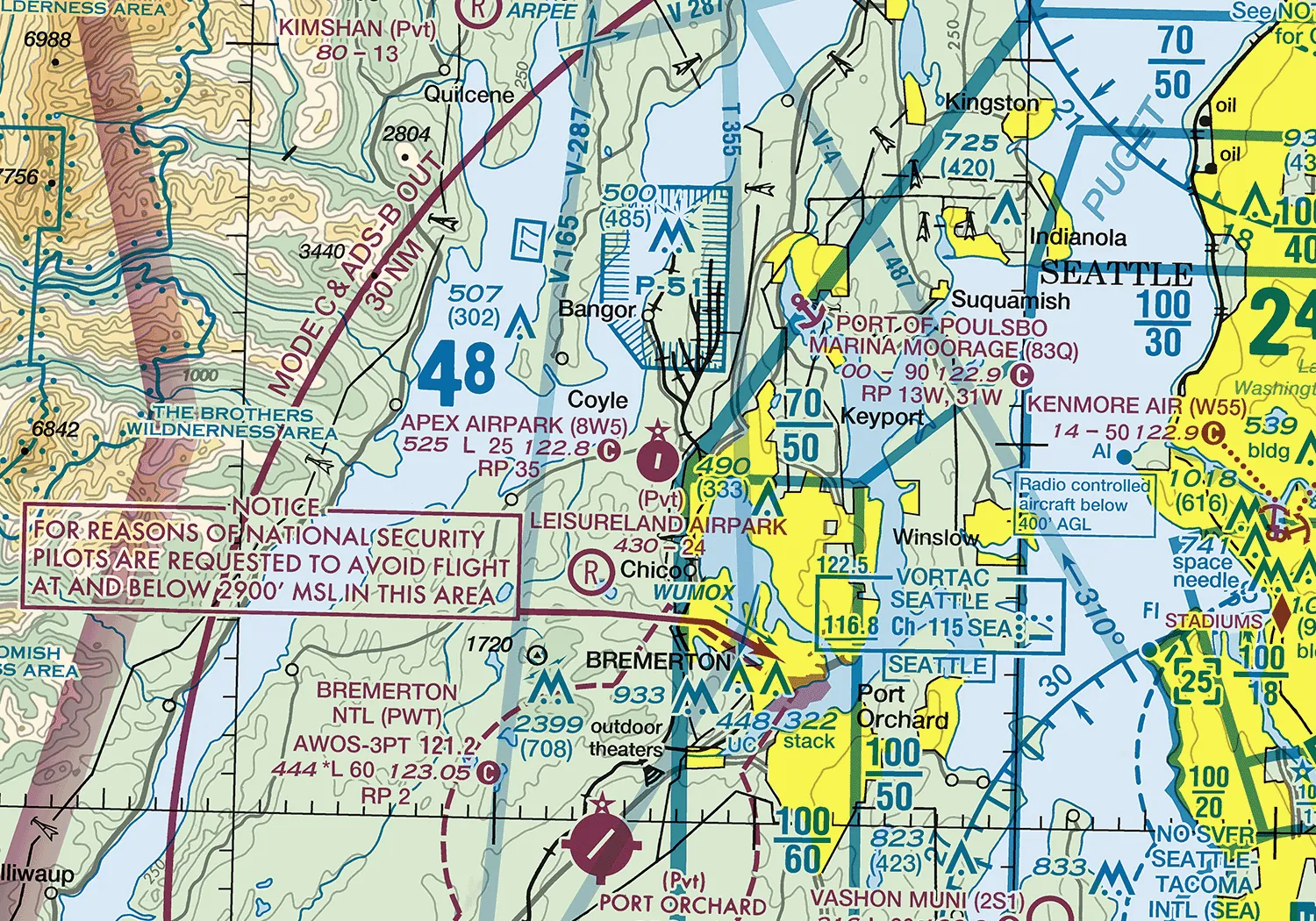
What is the approximate length of the longest runway at APEX AIRPARK (8W5)?
Refer to the image below to answer the question.
- 25 feet
- 250 feet
- 2,500 feet
Show the answer
Answer: C. In the airport data block, the number after "L" (or after the elevation) is the length of the longest runway in hundreds of feet, so 25 means about 2,500 feet.
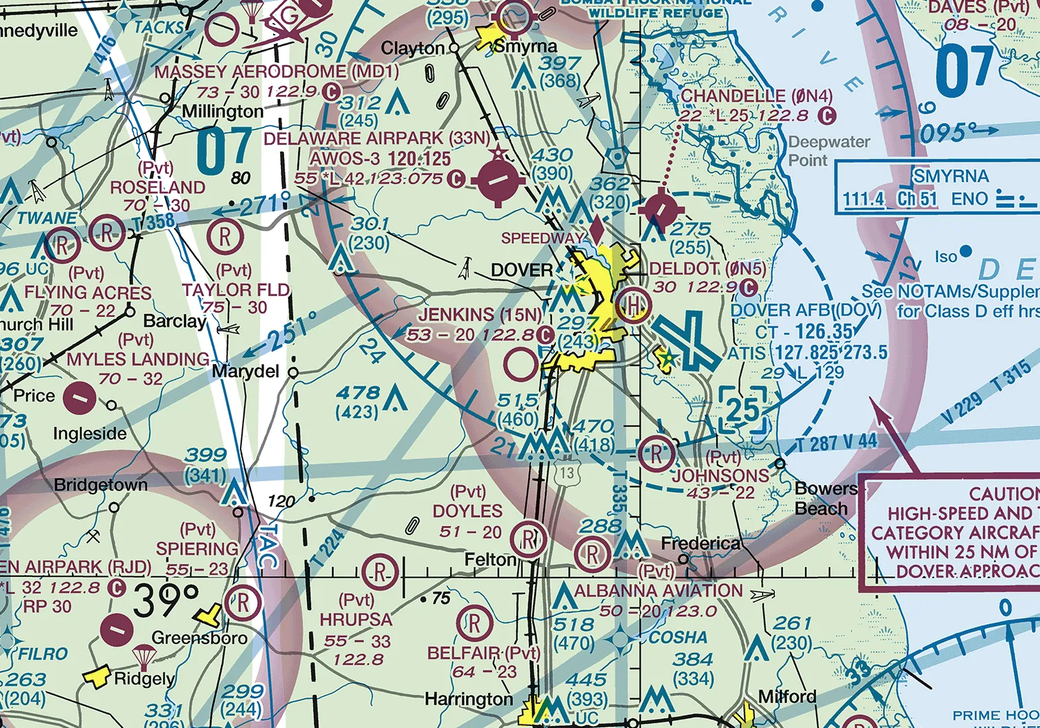
Which frequency is the Common Traffic Advisory Frequency (CTAF) at JENKINS (15N)?
Refer to the image below to answer the question.
- 122.8
- 122.7
- 123.05
Show the answer
Answer: A. In the airport data block, the CTAF is the frequency followed by the C symbol in a circle. The other frequencies near the airport name are for other services such as UNICOM, ATIS or an automated weather station.
Every question in the app has an explanation like these. Practice more for free.
Frequently asked questions
What does a magenta dashed line around an airport mean?
It marks a Class E surface area designated for an airport. Under 14 CFR 107.41 you need prior ATC authorization to fly a small UA inside it.
Do I need ATC authorization to fly near a non-towered airport?
Not if the site is in Class G airspace. AC 107-2A says no notification or authorization is needed at or near an airport unless the flight is in controlled airspace, though you must not interfere with airport traffic.
How is runway length shown on a sectional?
As the length of the longest runway in hundreds of feet, rounded to the nearest 100 feet with 70 as the rounding point. A runway of 8,070 feet is charted as 81 and one of 8,069 feet as 80.
Are obstacle heights on a sectional MSL or AGL?
Both may be shown. The top number is the MSL elevation of the top of the obstacle and the number in parentheses is its height above ground.
Sources
- FAA Aeronautical Chart Users' Guide (effective July 9, 2026)
- 14 CFR Part 107, Small Unmanned Aircraft Systems (eCFR)
- FAA Advisory Circular 107-2A, Small Unmanned Aircraft Systems
- FAA Remote Pilot - Small Unmanned Aircraft Systems Study Guide (FAA-G-8082-22)
- FAA Airman Testing Community Advisory, August 2026 Edition